This study delivered a refined deepwater reservoir characterisation that mitigated subsurface risk by systematically linking pore-scale flow heterogeneities to field-scale reservoir architecture. By integrating data from a latest-generation microresistivity borehole imaging (BHI) tool with large-volume rotary sidewall cores (RSWCs), Badley Ashton formulated robust geological scenarios for reservoir model inputs. This approach allowed for the definition of potential recoverable hydrocarbon ranges across different development cases.
By standardising descriptive and interpretive workflows across multiple data scales through a hierarchical approach, this study demonstrates that high-quality and fully integrated BHI and RSWC datasets offer a low-risk and cost-effective solution for infrastructure-led appraisal in mature basin settings.
This study was performed in conjunction with bp. We are grateful to bp for authorising the publication of this study.
Neal, A., James, A., Payne, D., Ashton, M., van den Beukel, N. and Storer, D., 2023. Integrated borehole image and rotary sidewall core data to support infrastructure-led appraisal: Capercaillie Field, Central North Sea. https://doi.org/10.1144/SP527-2022-184
In Neal, A., Ashton, M., Williams, L.S., Dee, S.J., Dodd, T.J.H. and Marshall, J.D. eds., 2023, November. Core values: the role of core in twenty-first century reservoir characterization. Geological Society of London. https://doi.org/10.1144/sp527-2022-184
The Capercaillie Field is situated down depositional dip within the prolific Sele Formation of the Central North Sea. Given its distal location, it presents a significant commercial challenge: identifying and accurately modelling typically smaller and lower net-to-gross hydrocarbon accumulations, where average sandstone permeabilities are commonly only a few tens of mD.
Badley Ashton addressed this challenge by utilising an integrated, multi-scale dataset to define geological architectures across the field more accurately. By linking these architectures to the sedimentological and petrographic controls on reservoir quality, the team facilitated a systematic de-risking process. This contributed directly to the assessment of the commercial viability of a potential tie-back to existing infrastructure by providing a reliable basis for volumetric estimations.
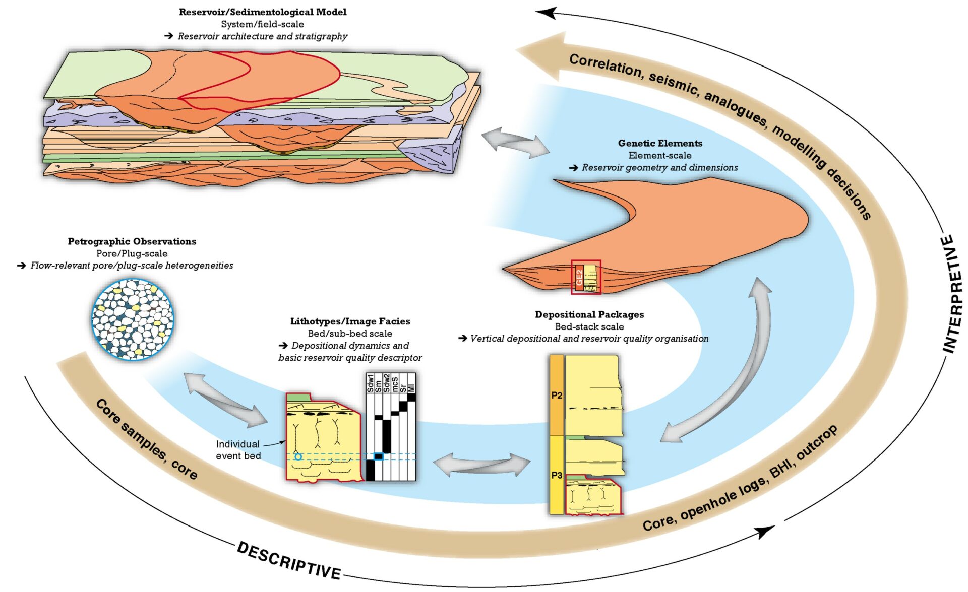
Figure 1. Badley Ashton’s hierarchical approach to deepwater reservoir characterisation. Descriptive bed and sub-bed scale lithotypes and image facies organise to define individual event beds, which in turn form depositional package bedstacks. The vertical and lateral organisation of the depositional packages, integrated with data from correlation, seismic and analogues, is used to define interpretative genetic elements that have associated reservoir geometries and dimensions. Quantitative petrographic and core analysis data can be coded by the hierarchical descriptors to understand the sedimentological controls on relative rock quality and carry reservoir quality understanding up and down the depositional hierarchy.
The study was founded on high-quality data from two wells: 29/04e-5 (vertical) and the deviated sidetrack 29/04e-5z, with a well separation of approximately 1850 m at reservoir depth.
The data available for formation evaluation comprised a full wireline log suite, high-resolution stratigraphic control from a separate biostratigraphic study, alongside:
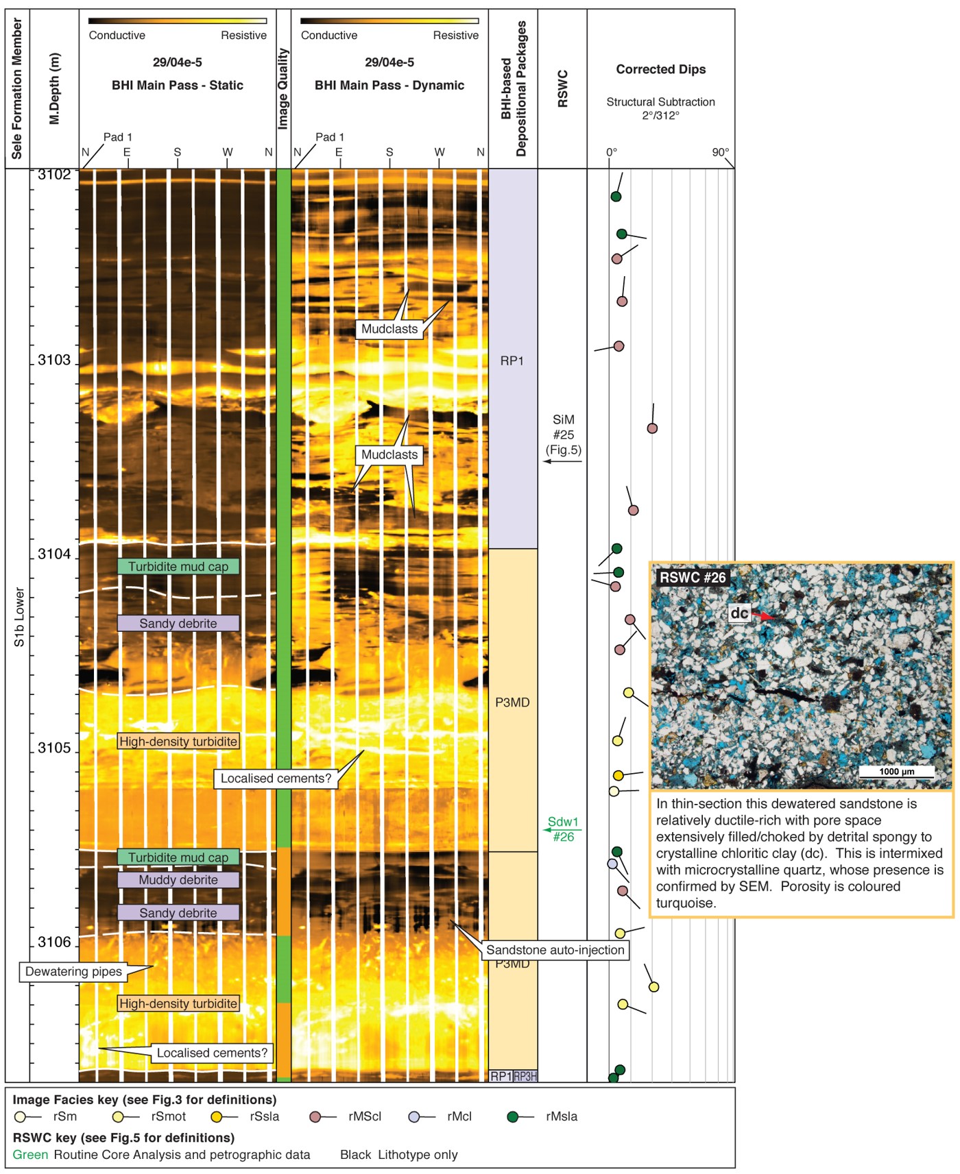
Figure 2. In the last 10 years, oil-based mud borehole images have reached a similar quality to water-based mud tools. This has revolutionised the imaging of deepwater reservoirs: mudclasts can be clearly distinguished from their sandy or muddy matrix allowing confident identification of conglomerates and debris flow deposits; fabrics and overprints within low-resistivity contrast sandstones are commonly imaged, such as dewatering, scours, deformation bands and even climbing ripple lamination; thin-bedded pay, such as that associated with channel-levee systems, can be much more accurately defined, allowing for improved sand counts and net-to-gross estimates.
The systematic integration and upscaling of all available data enabled clear geological and reservoir quality differentiation between stratigraphic units:
Architecture & Performance: Isolated channel-fill deposits were identified associated with the younger S2b and S1b Upper sandbodies in the 29/04e-5 well. Dominated by amalgamated sandstone depositional packages, they exhibited very good to excellent reservoir quality, with a mean helium porosity of 30.5% and geomean horizontal permeability of 445mD. Seismic and regional stratigraphic integration indicates that these channels were fed from the west by the shorter Bittern Fairway (Eldrett et al. 2015).
Petrographic Controls: The superior performance of the channel sandstones is attributed to their better sorting, low mean total clay content (<8%), low ductile content (<2%), and the presence of framework-stabilizing microcrystalline quartz.
Risk Mitigation: The penetration of the oil rim and oil-water contact in well 29/04e-5 confirmed the viability of the high-quality S2b sand as a primary development target.
Architecture & Performance: Stratigraphically older S1b Lower sandbodies are found in both wells. They represent complex stacked lobe deposits and associated hybrid beds. Even the best-quality axial amalgamated sandstone depositional packages within this unit suffer significant degradation. While they yield very good porosities (mean 24.5%), they exhibit moderate to poor permeabilities with a geomean of only 1.19mD. Off-axial debrite-dominated packages show even poorer reservoir quality, with permeabilities below 0.1mD. Regional studies place these older terminal lobes at the distal end of the West Axial Fairway of the main Forties Fan (Eldrett et al. 2015).
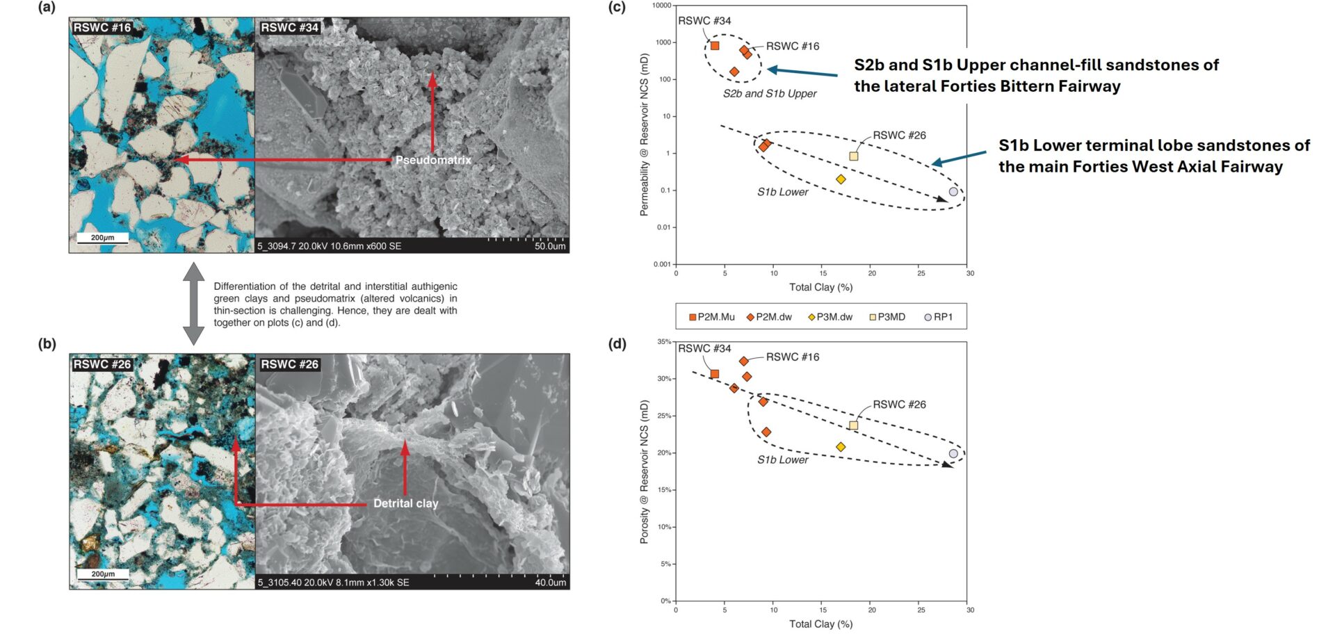
Figure 3. Sandstone Total Clay content plays a fundamental role in determining rock quality in the Capercaillie Field as it has filled pores, blocked pore throats and helped to facilitate compaction. The sandstones from the Bittern Fairway feeder channels display relatively low Total Clay (<8%) and ductile grain contents of <2%. In contrast, the sandstones of the main Forties West Axial Fairway terminal lobes have higher Total Clay (9-29%) and a mean ductile content of 11%. These characteristics, allied to the Bittern channel-fill sandstones’ better sorting, explain their much higher permeability and improved porosity. development of early framework-stabilising microcrystalline quartz and minor grain dissolution
Petrographic Controls: The fundamental barriers to flow within the S1b Lower sandstones are their relatively poor sorting, high concentrations of pore-choking total clay and the increased abundance of ductile grains, the latter two facilitating compaction. Total clay content within sandstones range between 9-29%, often as pseudomatrix from altered volcanic fragments. This petrographic signature likely reflects hydrodynamic fractionation of clay and volcanic fragments, associated with the long sediment transport paths of the West Axial Fairway, or simply their terminal lobe position.
The successful integration of wireline logs, borehole image interpretation, and targeted large-volume RSWCs provided a robust, data-driven understanding of the Sele Formation at the Capercaillie location. This insight directly informed capital allocation.
Badley Ashton delivered integrated stratigraphic, depositional, and petrographic framework which enabled the development of improved reservoir quality models to redefine of recoverable hydrocarbons, supporting critical decision-making for a range of development scenarios.
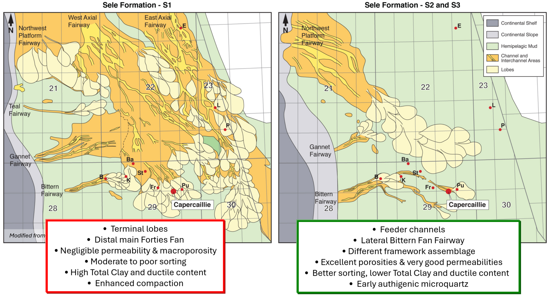
Figure 4. Summary of the stratigraphic, sedimentological and diagenetic controls on sandbody distribution, architecture and rock quality within the Capercaillie Field.