This study establishes a critical risk-mitigation protocol for reservoir characterisation in core-poor drilling campaigns. By quantifying the inherent limitations of using borehole images (BHI) alone, the research demonstrates that uncalibrated image interpretations introduce high uncertainty in reservoir models, potentially leading to incorrect static models that misrepresent sandbody geometry and dimension. The key financial takeaway is that a minor investment in establishing a calibrated core/image dataset vastly de-risks multi-million-pound field development decisions by improving geological certainty.
This technical presentation was delivered at the 6th EAGE Borehole Geology Workshop (21st-24th September 2025 – Montpellier – France).
Badley Ashton thanks Kuwait Oil Company (KOC) for authorisation to publish these results.
High-resolution reservoir characterisation, crucial for accurate static modelling and production forecasting, traditionally relies on the integration of BHI and wireline logs with ground-truth core data. When core acquisition is limited or absent the reliance on BHI interpretations increases. Determining the validity and confidence level of sedimentological and depositional interpretations derived from BHI alone, is challenging and can introduces inherent uncertainty into reservoir models.
This presentation aimed to quantitatively establish the degree of confidence that can be placed in single-well BHI analysis to correctly describe reservoir sedimentology and interpret detailed depositional environments in the Greater Burgan Field. The direct ROI is in quantifying the risk associated with core-poor wells; a clear understanding of BHI limitations allows operators to make informed decisions about core acquisition necessity, thereby preventing the development of significantly flawed reservoir architecture models which directly influence drilling location and field recovery estimates.
This case study used a single well penetration of the Lower Burgan Formation, Greater Burgan Field, South Kuwait.
This specific well was selected because it provided a unique dataset:
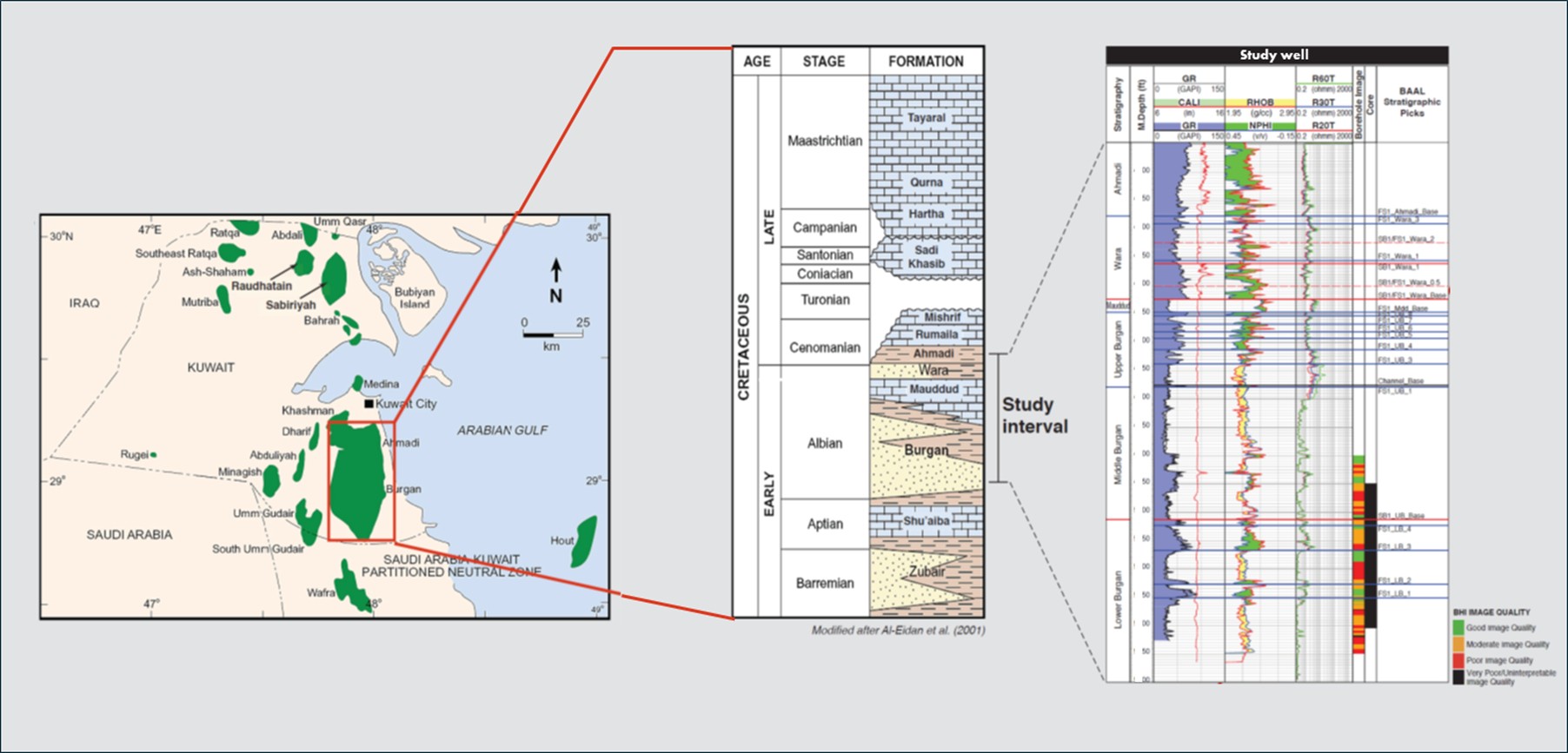
Figure 1 Location map, stratigraphy and dataset of the Study Well, Lower Burgan Formation, Greater Burgan Field, South Kuwait.
The methodology employed a rigorous, two-stage ‘blind’ testing approach applied to the BHI data:
Blind Interpretation: A robust, pre-existing image facies scheme (derived from previous core-calibrated studies) was applied to the BHI data without any prior knowledge of the study well’s core.
Core Calibration & Quantification: Detailed core description was subsequently integrated. The original ‘blind’ interpretation was then compared against the core-derived lithotypes to quantify the match. A final, second BHI interpretation, informed by the core, was then created to calculate the proportional change, establishing the overall confidence and accuracy of the BHI scheme.
The findings highlighted that several environmentally diagnostic features, critical for depositional modelling, fall below the image resolution threshold, directly impacting the accuracy of the resulting model (Figure 2 ).
Sub-Resolution Features: Thin, centimetre-to-decimetre-scale sandstone beds within mud-dominated heterolithics, wave ripples, ichnofacies/individual trace fossils, rooting, and mud-drapes were consistently missed by the BHI interpretation. Missing these subtleties in the Lower Burgan, for example, makes the differentiation between deltaic and more marine-dominated deposits significantly more challenging and crucially effects potential sand-body geometries.
Mismatched Interpretation Scale: Due to the inherent difference in descriptive scale, the full awareness of sedimentological detail was only achieved post-core integration. The lack of high-resolution detail leads to high uncertainty in the precise depositional origin, which can have a major, negative impact on sandbody dimension and geometry in the static model.
Image Advantage in Dip: Conversely, the study confirmed that BHI provides an advantage in deriving true, oriented dips for features like cross-stratification. Core processing, particularly slabbing orientation, can distort true dips, necessitating BHI integration to achieve accurate structural control.
The quantified results showed that while a calibrated image scheme provides a good baseline, the initial ‘blind’ test results were unreliable for final, detailed reservoir modelling until the crucial, but subtle, features missing from the BHI were incorporated from the core data.
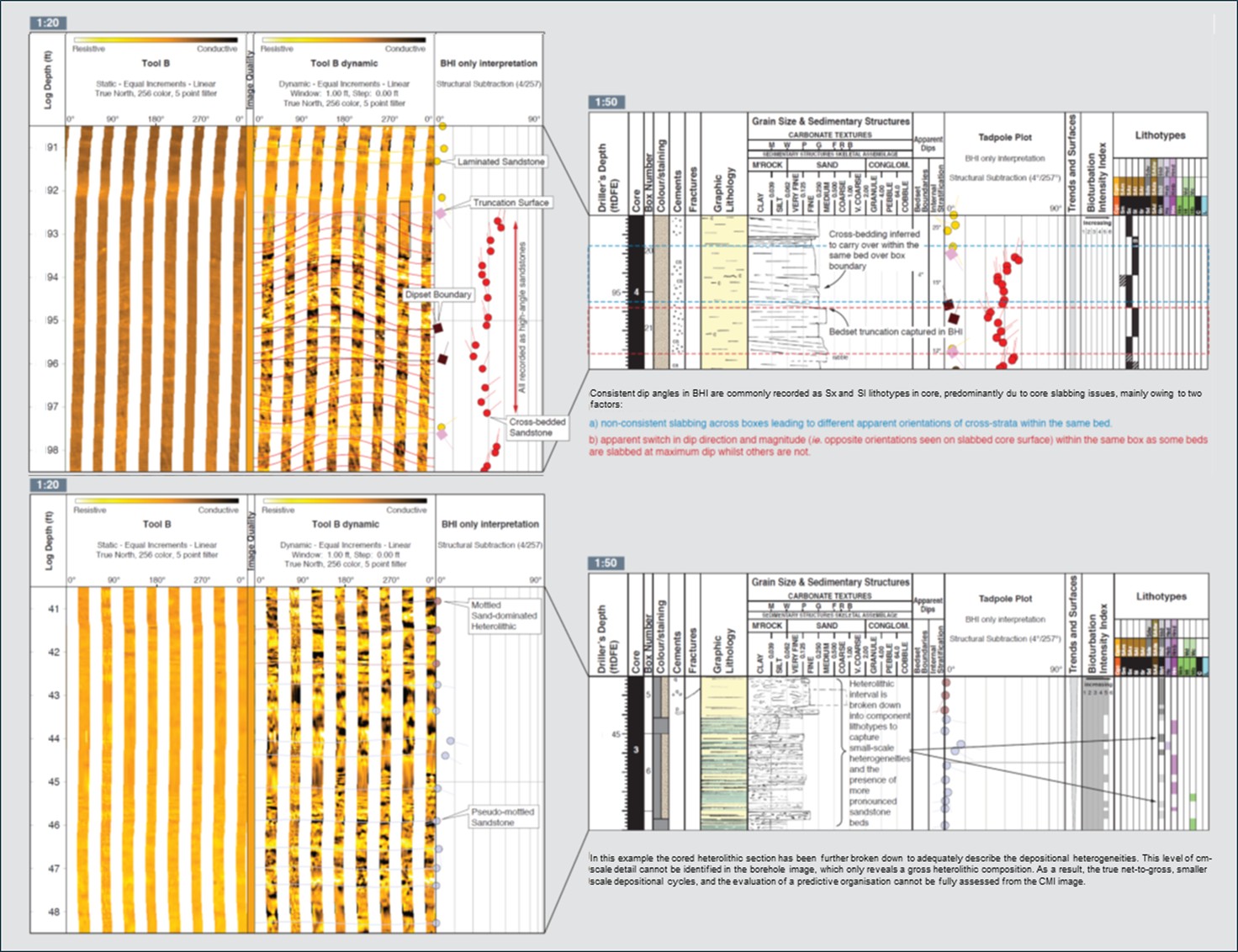
Figure 2 Impact of core slabbing and image resolution on core and BHI calibration. Common mismatches between image facies and lithotype datasets.
This case study highlights that while BHI can be an effective tool for reservoir description in core-reduced drilling programs, its stand-alone application carries a significant, quantifiable geological risk. The reliability of the interpretation is entirely dependent on establishing a well-calibrated core/image dataset specific to the stratigraphic interval and field first.
The study recommends the development of a comprehensive, stratigraphic-specific core-calibrated image dataset for all key reservoir intervals across the Greater Burgan Field prior to extensive, core-reduced drilling. The proven and calibrated scheme should then be applied to future BHI logs in core-poor wells. This ensures that the essential, sub-resolution, environmentally diagnostic features are accounted for through analogy, thereby minimally impacting geological certainty and significantly de-risking the next phase of the drilling campaign.